- Inspire
- Innovate
- Integrate
- Home
- Conserve Engineering Solutions UK Ltd
- Scan to BIM Services – UK
Scan to BIM Services – UK
Conserve offers Scan to BIM services in UK, 3D laser scanning that can transform the planning, engineering and construction of large-scale projects through data, visualization and business intelligent.
What is Scan to BIM ?
Scan to BIM is a transformative process that bridges the physical world with digital representations. It involves capturing accurate 3D data of existing structures or sites using advanced scanning technologies like LiDAR or photogrammetry, and then converting this data into intelligent BIM models. These models serve as comprehensive digital twins, facilitating efficient design, construction, and management of infrastructure projects.
How Conserve can help in the Scan to BIM
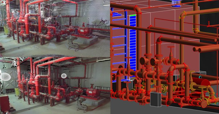
Scan to BIM: Conserve Solutions, specializes in serving our clients with the latest 3D laser scan to BIM technology with high accurate proximity data where field measurements or as-built will be a necessity.3D laser scanning of large, complex as-built structures helps AEC professionals accelerate the documentation process of existing conditions while improving accuracy and cutting costs. It helps to capture complete as-built field construction data without causing disruption.
Conserve offers onsite 3D laser scan to BIM, delivering high-definition scans for immediate Engineering analysis. The 3D scans deliver high definition 360-degree by 320-degree photo-realistic panoramic scans to a 3D CAD surface model. The 3D digital capture gathers large amount of field information in short period. The data from point cloud/3D scan can be used to produce engineering documents without clashes and interferences.
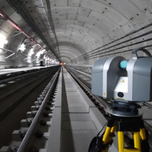
Conserve’s 3D scan to BIM services start by bringing our qualified technicians out to your site for digital survey, scanning and data collection.
Data Collection
First, we set up our digital survey total stations to validate scanner positions for each area that needs to be captured. These surveys dimensional control methodologies offer a higher standard of precision, ensuring that the resulting point cloud modelling is accurate within 2mm to 5mm. Secondly, laser-scanning devices take 360-degree laser measures of reflected surface points that are collected / measures millions of points per second. Once all the scans are collected, the data is taken in-house.

Data Analysis
Thirdly by using the state-of-the-art processing software where all the individual scans are registered and connected together to form your unique point cloud scan to BIM model which suits as an input into BIM applications.

Data Processing
Scan to BIM: 3D scanned data can be integrated with other information in CAD, GIS & Web platforms where engineers to make informed real time decisions can use it. When integrated with BIM, the point cloud scan to BIM process allows you to quickly and accurately analyse and access as-is project conditions prior to commencing the design process. The 3D point clouds will be converted into a comprehensive Building Information Model in native formats
Advantages of 3D Laser Scan to BIM Over Conventional Method
Proven lower cost as-built and topographic surveys, due to faster data collection & shorter project life cycle times.
Proven lower cost as-built and topographic surveys, due to faster data collection & shorter project life cycle times.
More accurate, complete as-built for retrofits and design, enabling offshore fabrication & less construction rework caused by Interferences and fit-up problems
More accurate, complete as-built for retrofits and design, enabling offshore fabrication & less construction rework caused by Interferences and fit-up problems
Reduced facility downtime, because of the unobstructed scanning procedure.
Reduced facility downtime, because of the unobstructed scanning procedure.
Scan data can be delivered via a complimentary viewer, as 2D or 3D CAD or in a variety of laser scan formats that can be manipulated by the client.
Scan data can be delivered via a complimentary viewer, as 2D or 3D CAD or in a variety of laser scan formats that can be manipulated by the client.
Time spent for data capture is up to 10 times faster, and then construction / installation stop of shorter duration.
Time spent for data capture is up to 10 times faster, and then construction / installation stop of shorter duration.
We can be sure that all the necessary information have been collected, allowing us to avoid the risk of having to return to the site to integrate with new measures.
We can be sure that all the necessary information have been collected, allowing us to avoid the risk of having to return to the site to integrate with new measures.
How Scan to BIM in UK supports to the BIM Industries
01
Buildings – Architecture, Structure, MEP and its Utilities Infrastructure
02
Urban Planning
03
Highways & Transportation Infrastructure
04
Off-shore – Oil rigs & Vessels
05
Industrial Applications – Power Stations / Power Plant
Features
- Photo Measure: Real-time measurements from a photo
- Point-to-Point: Measure the distance between two objects
- Highways & Transportation Infrastructure
- Measure Remote Objects and Collect GPS/GNSS Location from a Distance
- Export and share captured photos and measurements
Why Choose Conserve Solutions?
Proven Track Record
We have a proven record of accomplishment of successfully delivering Scan to BIM services in the UK, for a diverse range of projects, from small-scale renovations to large-scale infrastructure developments.
Cost-Effectiveness
Our cost-effective Scan to BIM services in the UK help optimize project budgets by minimizing rework and maximizing efficiency in the design and construction phases.
Collaborative Approach
We believe in fostering strong partnerships with our clients, working closely with them throughout the entire project lifecycle to ensure their needs are met and expectations exceeded.
Client Satisfaction
We prioritize client satisfaction above all else, striving to deliver exceptional results that consistently exceed expectations.
Are you ready to explore your journey with BIM services? Reserve your spot now for the UKCW Event on 7- 9th May 2024!
Frequently asked questions
FAQ's
Scan to BIM is the process of capturing 3D data of existing structures and converting it into intelligent BIM models.
Scan to BIM reduces errors, minimizes rework, and improves collaboration among stakeholders.
Common scanning technologies include LiDAR, photogrammetry, 3D laser scanning, and structured light scanning.
Steps include scanning, processing data to create a point cloud, generating a 3D model, and integrating it with BIM software.
Scan to BIM benefits architectural renovations, infrastructure upgrades, facility management, historical preservation, and construction planning.
Using Scan to BIM in UK allows local AEC professionals to leverage advanced 3D scanning technology with high accuracy and timely delivery, ensuring compliance with regional standards and smoother project execution.
Our 3D scan to BIM in UK delivers accuracy within 2mm to 5mm, ensuring reliable as-built documentation and eliminating costly rework during the design and construction phases.
Absolutely. Our cost-effective Scan to BIM services in UK minimize errors, reduce rework, and maximize efficiency, helping clients save both time and money on projects.
Get in touch
Have any other questions?
Are you ready to elevate your design journey? The SCAN to BIM revolution begins now!
Quick Links
Copyrights © 2026. Conserve Solutions. All Rights Reserved.
BIM Data, Cost & Handover Services
BIM Coordination & Constructability
BIM Modelling & Digital Delivery
Discipline BIM Modeling (Architectural, Structural, MEP)
BIM Automation & Digital Engineering
BIM Data, Cost & Handover Services
Structural & Steel Detailing Services
Architectural Design, Visualization & Presentation Support
BIM Coordination & Constructability
BIM Modelling & Digital Delivery